Geodetic Measurements
Geodetic surveying is labour-intensive and time consuming work, which bears considerable cost, but is necessary for almost any economic activity. At the same time surveying of the vast
areas of Canada, and also of Alberta, is a challenging task because of their remoteness and difficulty of access for surveying teams.
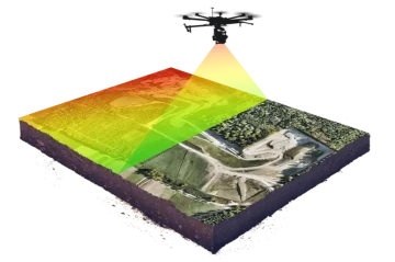
Using the UAV FPV drones can address this problem. The FPV drone, which is equipped with GPS receiver and LiDAR (LiDAR, the Light Detection and Ranging) sensors can take the Earth surface
altitude at any location, and at a number of points that the control center's computer can handle, all without sending the surveyor team to the field. The product of the LiDAR scanning is,
essentially, a multispectral image, which carries more information that just an altitude at the probed location, and can be processed using well developed methods of the
satellite Earth Observation. Geodetic surveying using UAV drones and LiDAR is already used by some European countries.
This method is less effective for the forested areas, but can be effective and cost-saving for the Prairies, and for Canadian North.